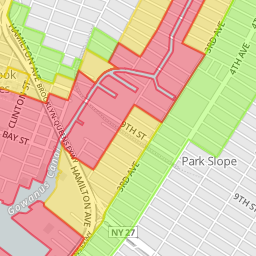
 Looks like ti might not be a great idea to go to Fairway in Red Hook on Monday. If the storm hits NYC, Red Hook is just one of the areas at high risk for flooding. 370,000 people in NYC live in ;ow-lying areas including Red Hook, Coney Island and other areas around the East River in Brooklyn, the Rockaways, Broad Channel, the Staten Island coast line, City Island, Battery Park City, stretches of the West Side waterfront, the Lower East Side and the East Village.
The map above is from the NYC.gov website, which contains a lot of information.
RED: Residents in Zone A face the highest risk of flooding from a hurricane’s storm surge. Zone A includes all low-lying coastal areas and other areas that could experience storm surge in ANY hurricane that makes landfall close to New York City.
YELLOW: • Residents in Zone B may experience storm surge flooding from a MODERATE (Category 2 or higher) hurricane.
GREEN: • Residents in Zone C may experience storm surge flooding from a MAJOR hurricane (Category 3 & 4) making landfall just south of New York City.
